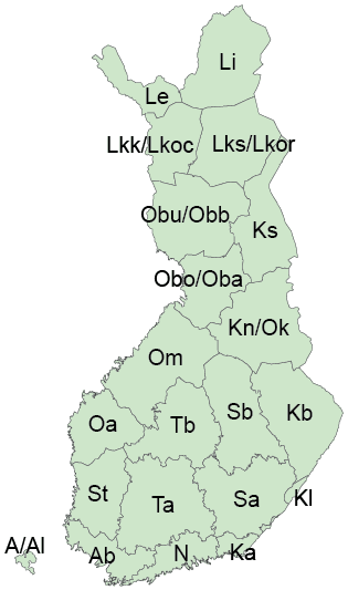
Finnish Biogeographical Provinces
Background
Biogeographical provinces are areas that have traditionally been used to depict species distribution, as the highest-level sub-regions of Finland. They are commonly used e.g. on distribution maps on identification guides and other publications.
Biogeographical provinces ("eliömaakunnat" or "luonnontieteelliset maakunnat" in Finnish) are based on municipality borders of 1930. Because municipality and other administrative borders have changed over time, the provinces are not strictly following any current administrative regions. There have been few slightly differing versions of the provinces. FinBIF uses borders based on digitization work done at the Botanical department of the Finnish Museum of Natural History.
Original biogeographical provinces from 1930's reached the Arctic Ocean in the east, and eastern part of Lake Ladoga in the southwest. The current area of Finland comprises of 21 biogeographical provinces.
Each biogeographical province has a Finnish and a Latin name, as well as Finnish and Latin abbreviations. Entomological literature has used some alternative names for the provinces in North Finland. These have been marked with yellow background color on this table.
Table of biogeographical provinces
