Myrmeleon formicarius
- Overview
- Images
- Identify
- Taxonomy
- Occurrence
- Specimen
Finnish taxon
Yes
Occurrence in Finland
Publicerad från Finland
Primary habitat
- Rih – sandstränder
Status in Finland
- Väletablerat
Publication of occurrence
- Rintala, T., Kumpulainen, T. & Ahlroth, P. 2014: Suomen Verkkosiipiset. 184 pp, Tibiale, Helsinki.
- Teemu Rintala, A. Albrecht (FMNH) / V. Rinne (ZMT) / Hemiptera Expert Group 2013: Atlas of the Neuroptera s.l. and Mecoptera of Finland / Suomen verkkosiipis- ja kärsäkorentoatlas / Atlas över Finlands nätvingar och näbbsländor 2012. [http://biolcoll.utu.fi/hemi/neur/verkmaps.htm (Updated: 1.3.2013 )]
LINK
Observations in Finland
The map represents observations of this taxon, but it may not be used as a distribution map.

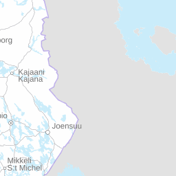


Click before zooming
squares
Observations
- Total squares
GBIF
The map represents observations of this taxon, but it may not be used as a distribution map.


Click before zooming
Distribution by biogeographical provinces according to expert evaluation
- Förekommer på grundval av händelsedata – inte en expertbestämning
Observations per month in Finland
Click on the legend to filter results
Observations per year in Finland
The chart shows temporal distribution of the observations, which is not the same as population increase/decrease.
Habitat
The following biotope data have been recorded for observations of this taxa
Record type
Observation
142
Prov
35
Livsfas
larv
48
vuxen
47
juvenil
1
nymf
1
spår
1
Kön
hona
2
Datasets and collections