Lypoglossa
- Overview
- Identify
- Taxonomy
- Occurrence
- Specimen
Finnish taxon
Yes
Observations in Finland
The map represents observations of this taxon, but it may not be used as a distribution map.

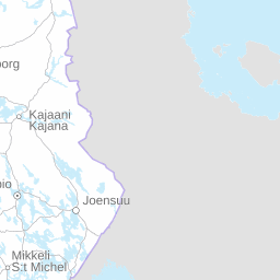


Click before zooming
squares
Observations
- Total squares
GBIF
The map represents observations of this taxon, but it may not be used as a distribution map.


Click before zooming
Distribution by biogeographical provinces according to expert evaluation
- Occurs
Observations per month in Finland
Click on the legend to filter results
Observations per year in Finland
The chart shows temporal distribution of the observations, which is not the same as population increase/decrease.
Habitat
The following biotope data have been recorded for observations of this taxa
Record type
Preserved specimen
677
Observation
29
Life stage
adult
141
immature
9
Sex
M - Male
15
F - Female
12
Datasets and collections